Jason Segedy, planning director in Akron, OH, had an interesting Twitter thread that got turned into a City Observatory article about “displacement by decline” (what I’ve termed as “displacement without development” in this series). Like many Rust Belt cities, Akron is losing both income and population. Segedy writes:
There are articles and blog posts aplenty focusing on the (very real) improvements in a small handful of revitalizing neighborhoods…But it is all-too rare to read anything about the equally very real, and worsening, problems of poverty, disinvestment, and segregation that affect exponentially more urban residents in these cities.
We hear a lot about the potential evils of hipsters, coffee shops, and bicycles, along with murky allegations of displacement by gentrification, levied by activists and academics.
We hear far less about the primarily black middle class residents fleeing previously stable urban neighborhoods for the suburbs each year (displacement by decline), while the poor are left behind in crumbling communities, trapped in concentrated generational poverty.
Cities are dynamic, fluid, and geographically diverse places, which are revitalizing in some areas and declining in others.
He goes on to assert that “Gentrification has become a useless word,” and I think that’s an important thing to think about. It’s part of why I did this series. Urban dwellers throw around that term in lots of different ways, referring to displacement, cultural change, and reinvestment. Those are not identical issues, and they require different approaches.
When I was studying in Berlin, one of my professors said there was a German phrase which translates to, “Anyone who can pronounce ‘gentrification’ is contributing to it.” I’m sure that’s particularly true in German (gentrifizierung). The term is academic and wonky. Sometimes it’s used by entitled whites who are annoyed about being displaced by more-affluent entitled whites. I would challenge advocates to use language which is more clear about what phenomenon they are trying to describe; “gentrification” is just too fuzzy and broad.
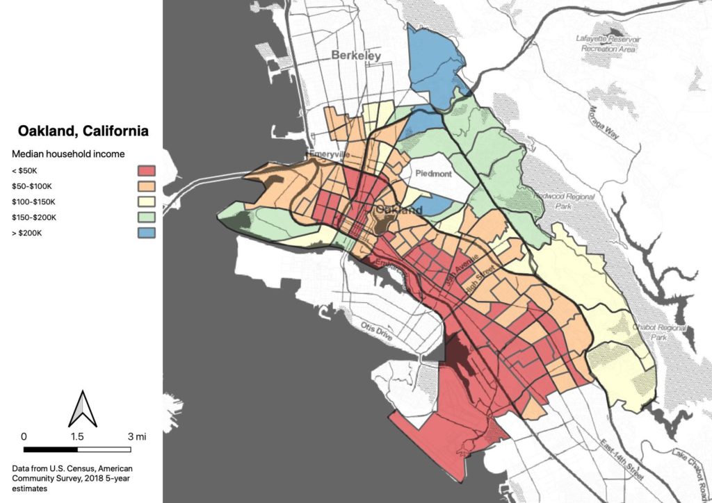
I also would challenge advocates to think about who is included and excluded in conversations about neighborhood change and displacement. In Oakland, we spend a lot more time talking about what’s happening on MLK and in West Oakland than we do talking about what’s happening on International in East Oakland. Blacks are being displaced in both places, but in East Oakland they’re being displaced predominantly by low-income Asians and Hispanics. Is that issue not as prominent because no Whites are involved?
Corridor analysis
This project interested me because I’m a transportation geek, and transportation geeks think in corridors. A lot of our corridor data isn’t readily available at scale, so being able to use MLK Way to look at corridors across the country was kind of novel. I was able to generate some really cool (to me) data to play around with. And even at the level of the individual city, it may be useful to analyze different divisions within the city. For example, here is the non-White population along International, MacArthur, and Skyline in Oakland:
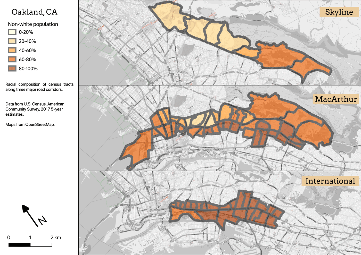
It’s interesting that the southeast portion of the city above 580 near the zoo is over 60% people of color. It’s also worth noting that the only place along International that’s less than 80% POC is the new warehouse district south of Jack London Square. And doesn’t that jumble along MacArthur look fascinating? Take the AC Transit 57 from MacArthur BART to 106th Avenue sometime if you want to learn about Oakland neighborhoods.
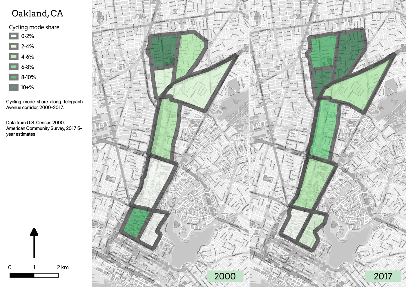
I can also ask questions about bike corridors, such as, how has bike mode share changed for people who live near the protected bike lanes on Telegraph? (Not as much as how it’s changed in Temescal, it looks like):
There is plenty of opportunity to investigate a wide range of questions using this platform, and I’ll be looking forward to messing around with it more.
Conclusion (really)
Here at the end of Black History Month, I would remind everyone—after first reminding myself—that everything we do in American cities is done in an environment that’s been shaped by racial exclusion. And in the Industrial Age, that’s particularly and especially true of transportation corridors. The streetcar suburb, urban renewal, BART, the expansion of freeways, and even the freeway revolts, are rooted in a deep history of power used against communities of color, Blacks in particular. The redlined, disinvested, racially segregated neighborhoods which Blacks were forced to inhabit often became the places where a street later was dedicated to Dr. Martin Luther King, Jr., who gave his life fighting for justice for the Black community.
Today, those MLK Way neighborhoods are changing in different ways. In Oakland, where MLK Way marks the border of the historical red line, the neighborhood is developing, and in the process displacing the Blacks who once defined the place. Cities like Cleveland are experiencing displacement without development; disinvestment is ongoing, as people continue to move away from the decaying neighborhood. In formerly White suburbs like Staten Island, the suburbanization of poverty is resulting in resegregation. And in a few (very few) cities, like Washington DC, it looks like the neighborhood may be developing without displacement. Is there something to learn from DC that can be applied elsewhere?
The biggest lesson I take from this project is that urban Black communities (and disadvantaged communities in general) have complex challenges, and those of us who care about equity and social justice need to grapple with that complexity. “Gentrification” is a reductive term which avoids meaningful engagement.
For further reading, Ta-Nehisi Coates published an important and detailed piece on The Case for Reparations, which got some play on NPR but did not make any real headway as policy. Richard Rothstein recently published “The Color of Law”, also detailing how governmental policy led to segregation and disadvantage, and also getting some play on NPR and at several events in Oakland. Robert. O. Self’s “American Babylon: Race and the Struggle for Postwar Oakland” is a powerful analysis of racial exclusion after WWII, the Civil Rights movement and the Fair Housing Act of 1968. I recommend it to everyone who loves Oakland.
In the end, while all of this is definitely Black History, it’s also White history. The suburbs, the freeways, the mortgage deduction, the tax revolt, and neoliberalism in general have granted me, and Whites like me, innumerable unearned advantages. Those of us who believe in social justice as a concept, and who have benefitted from racist policies advantaging us and our families, need to learn to participate in social justice as a practice.
References
Boeing, G. 2017. “OSMnx: New Methods for Acquiring, Constructing, Analyzing, and Visualizing Complex Street Networks.” Computers, Environment and Urban Systems 65, 126-139. doi:10.1016/j.compenvurbsys.2017.05.004
David Rumsey Historical Map Collection, “Map illustrating the Siege of Atlanta, Ga.” Edward Molitor, Lith. 1864.
David Rumsey Historical Map Collection, “Shell Street Guide and Metropolitan Map Atlanta (cover title). Shell Street Map of Atlanta. 12-DD-1956-1. (inset) Downtown Atlanta.” Shell Oil Company. 1956.
Ebrahimi, Farhad, “How to think about power (especially if you have some)”, Chorus Foundation, <https://www.ncrp.org/publication/responsive-philanthropy-february-2019/how-to-think-about-power-especially-if-you-have-some>. Retrieved Feb 24, 2019.
Google Earth Pro V 7.3.2.5495. (October 31, 2018). Denver, Colorado, 39°46’25.04″ N 104°52’36.09″ W. [January 31, 2019]. https://www.google.com/earth/versions/
QGIS Development Team (2019). QGIS Geographic Information System. Open Source Geospatial Foundation Project. http://qgis.osgeo.org
“Project Jupyter.” Project Jupyter, jupyter.org/.
Segedy, Jason. “Displacement by decline.” (2019, January 02). Retrieved from http://cityobservatory.org/displacement-by-decline/
U.S. Census Bureau. 2000 Census.U.S. Census Bureau, 2000, API. <http://www.census.gov/prod/cen2000/>.
U.S. Census Bureau (2017) 2012-2017 American Community Survey 5-year estimates. Retrieved from https://api.census.gov